Sequoia NP on Labor Day weekend

조회 수 1867 추천 수 0 2013.07.09 14:07:14
Labor Day Weekend에 계획되었던 건우회 Camping Trip은 충분한 참가자가없어 cancel되었습니다.
하지만 저는 개인적으로 Sequoia National Park의 Lodgepole Campground를 다음과 같이 예약했습니다.

관심이 있으신분들은 제게 연락주십시요.
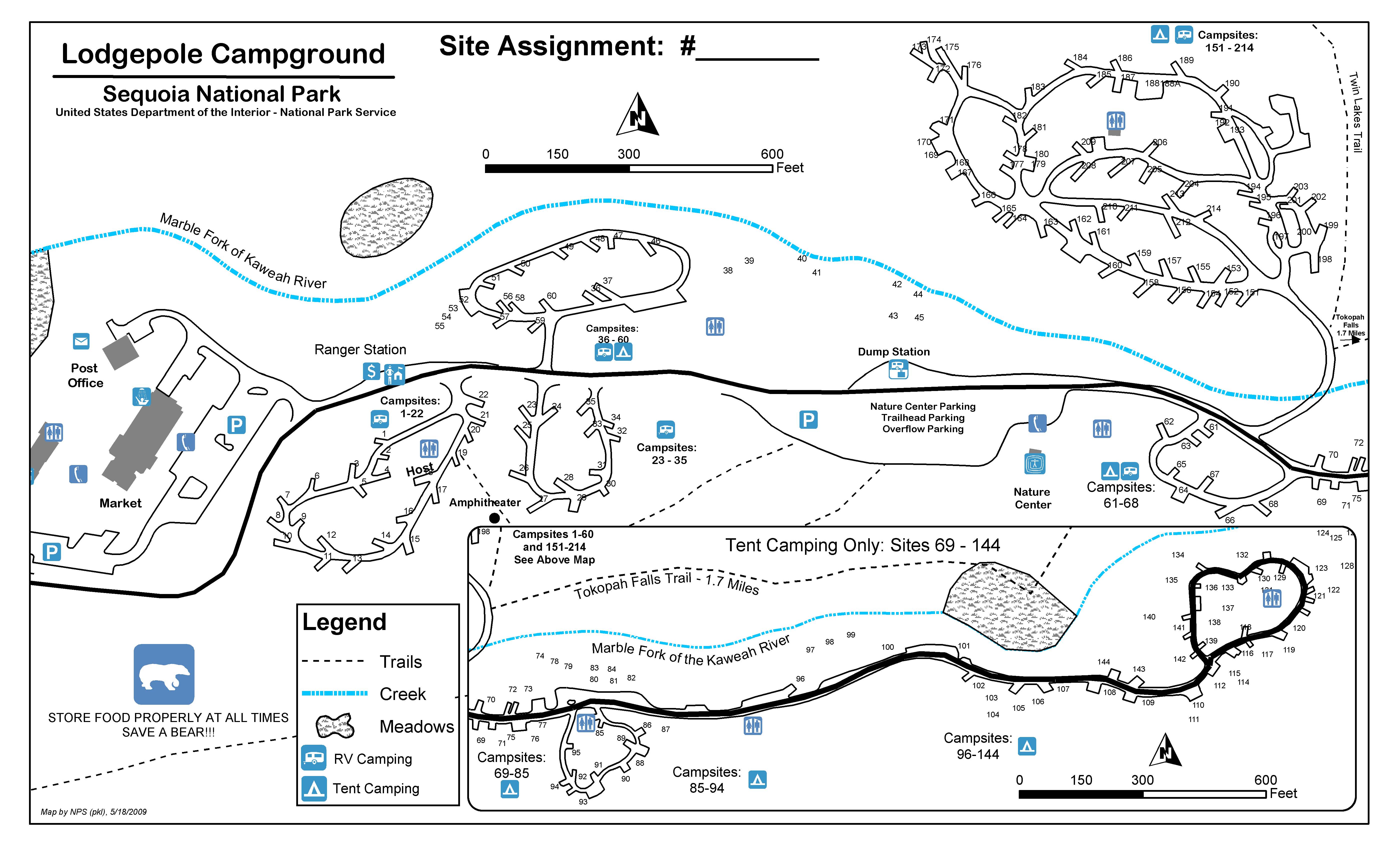
Campground: LODGEPOLE SEQUOIA NATIONAL PARK

Site: 056 Loop: 36-60 Region: WRO

Arrival Date: Sat Aug 31 2013 Departure Date: Mon Sep 2 2013 Length of Stay: 2

Primary Occupant: SCOTT KIM # of Occupants: 6 # of Vehicles: 2

Check-In Time: 12:00 PM Check-Out Time: 12:00 PM                       

Overflow Parking available at Nature Center Parking / Trailhead Parking


Hiking:  Tokopah Falls on August 31, 2013: Easy 1.7 mile (one way) walk along the Marble Fork of the Kaweah River.

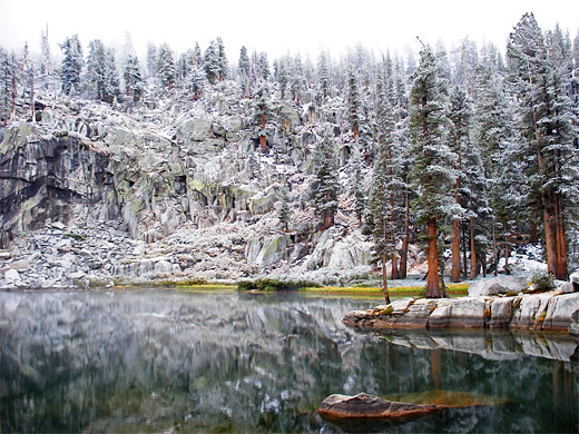
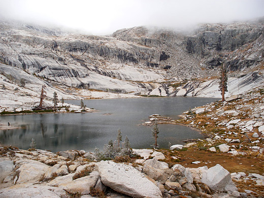
            Lakes Trail  on September 01, 2013: 6 mile route leading to Heather, Emerald, Aster and Pear Lakes.


Heather Lake
Because of the dramatic and varied surroundings, the Lakes Trail provides the best day hike into the high Sierra backcountry ofSequoia National Park. The 5.8 mile route passes through thick forest and along the rim of a deep canyon, then leads to four glacial lakes in the middle of a stark granite landscape, equal in beauty to anything in Yosemite National Park, which is generally better known for mountainous scenery than Sequoia. The path gains 2,270 feet in elevation, mostly over the first few miles, but the route is relatively easy and the round trip quite possible in about 6 hours.

The Trailhead: The path begins by a large car park at the Wolverton ski/picnic area, reached by a 1.5 mile side road from the Generals Highway. It enters the forest, turns right at a junction after 150 yards then begins a long steady climb up a wide ridge. On the north side the land falls away steeply, 800 feet down to the valley of the Marble Fork of the Kaweah River, site of the Lodgepole visitor center, though this canyon is mostly hidden by trees. The south side of the ridge slopes to a much shallower valley, with a small stream running through (Wolverton Creek), and patches of marshy meadowland. The forest is quite open, filled by pine trees of all sizes, many partly covered by moss and some surrounded by clusters of ferns - the woods seem to receive quite a lot of rainfall. The path curves a little to the south, crosses a few granite outcrops and a small creek, then reaches a junction (1.7 miles from the start); the right branch leads to Panther Gap after 0.9 miles then continues to many places further east, including Alta Peak, Alta Meadow and a junction with the High Sierra Trail.


Pear Lake
Heather Lake: The left fork (to the lakes) climbs another 250 feet and re-crosses the small stream, now flowing through a thin green corridor of grass and ferns between tall pines at either side. The path splits just beyond, both branches rejoining further on, and although the right part of the loop - the Hump - is 0.2 miles shorter, the left half (the Watchtower route) has less elevation gain and better views, so is normally preferred. It is nearly level for a while but soon begins a continuous ascent, gaining nearly 1,000 feet while passing several viewpoints right on the edge of sheer cliffs high above the upper end of Tokopah Valley and the Kaweah River. The trail cuts across vertical cliffs for a way, with a long drop to one side. After a small descent to a flattish area, and the junction with the other branch of the trail, Heather Lake comes into view. This has a secluded location in a bowl-shaped chamber at the foot of steep, streaked, granite cliffs, enclosed by trees and jagged boulders, and comes as a pleasant surprise after the preceding miles of mostly gloomy forest.

Other Lakes: The path continues up and over a ridge, where the trees fade away, replaced by miles of pure granite wilderness. The smaller Aster Lake sits 200 feet below, partly hidden behind a thin belt of woodland, while lake number three (Emerald) is just ahead, a short distance off trail. This is similar to Heather except for the lack of trees, and although its enclosing cliffs are not quite as steep, the lake is just as pretty. Walking onwards, the path turns to the north, rounds the end of a high, narrow ridge, and reaches a final junction with a short spur to the Pear Lake Ranger Station. The final 0.6 miles to Pear Lake climbs a little, passing over a field of boulders to the edge of the water, at elevation 9,550 feet. Pear is the largest lake and has especially imposing cliffs on the far side, formed of pale grey granite and like many of the rocks hereabouts are streaked with vertical black bands left by the corrosive action of rainwater and melting snow.


photograph
Rocks by Emerald Lake
photograph
Reflections on Pear Lake

삿갓

2013.07.14 18:37:42
*.95.239.87

2013-07-14 현재로, 한팀 (1-2people) 정도 더 가능합니다.


Scott Kim

2013.08.30 20:52:16
*.252.174.99

List of Articles
번호 제목 글쓴이 날짜 조회 수sort
297 云蒙山 file [2] Han Kim 2010-12-20 3795
296 수면 요령 10가지 망일산 2011-05-11 3779
295 비만의 원인이 장내 세균? [2] Han Kim 2010-11-02 3770
294 [건강상식] 고구마에 이런 힘이 있었네 [2] 샤인 2011-03-31 3770
293 미국의 길 이름(미주중앙일보) 샤인 2010-07-07 3763
292 박정희 대통령에 대한 세계인의 평가 [3] 샤인 2010-12-31 3756
291 Mt. Baden Powell by Dawson Saddle on 09-11-2010 [1] Scott Kim 2010-09-09 3748
290 독립기념일 연휴 등산- Taft Point & Sentinel Dome사진 file Sunshine 2010-07-11 3738
289 뇌내혁명; 플러스 발상법 [2] Sunshine 2010-12-03 3728
288 친구 [2] Chi Ho Ham 2010-08-18 3707
287 이거 우짜겠노? 샤인 2011-07-04 3642
286 발암물질? 영양소 파괴? "근거없다"(중앙일보) [2] 샤인 2015-03-10 3625
285 마음 가는 대로 [2] Chi Ho Ham 2011-05-11 3619
284 한반도에 드리운 중국의 그림자 [3] Han Kim 2010-10-13 3617
283 신이 주신 천연 면역증강제, 피톤치드 [3] 샤인 2010-07-08 3613
282 사진작가 패트릭 노트레이 샤인 2011-06-25 3601
281 위대한 지도자와 훌륭한 관료 [2] Han Kim 2010-11-10 3598
280 월드컵의 Kumbaya 샤인 2010-06-30 3574
279 10 Essencials in Hiking [4] Scott Kim 2010-10-05 3569
278 떫은 감으로 만든 곶감에서 어떻게 단맛이 날까? 샤인 2010-04-29 3559